
AccuWeather: Powerful storm to bury interior Northeast under heavy snow
Powerful storm to bury interior Northeast under heavy snow
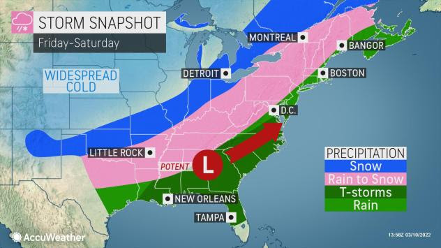
The table is set for a late-winter helping of snow, ice, pounding winds and heavy rain in the eastern United States as a dynamic storm system tracks from the Gulf Coast, through the Northeast and into Atlantic Canada from Friday into Saturday.
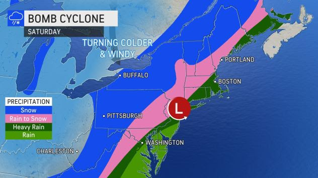
AccuWeather Global Weather Center – March 10, 2022 – More than 150 million people will face some type of impacts from the storm east of the Mississippi River, but the Northeast, which received accumulating snow on Wednesday on the heels of record-challenging warmth on Monday, is likely to take the brunt of the impacts as the storm rapidly strengthens into a bomb cyclone along the Eastern Seaboard.
A storm becomes a bomb cyclone or undergoes bombogenesis when the atmospheric pressure at the center of the storm plummets by 0.71 of an inch of mercury or more within 24 hours. This particular storm will likely far exceed that criteria with the central pressure forecast to plummet close to 1 inch of mercury from Friday evening to Saturday evening.
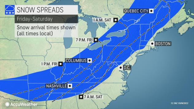
From a travel standpoint alone, major disruptions are likely on the roads and for those flying. Flight delays and cancellations are anticipated and could result in ripple-effect impacts across the country. Even though the snow portion of the storm is likely to only last 8-12 hours and perhaps only a few hours in some areas, impacts will be significant.
The storm will first take shape along the central Gulf coast on Friday evening before it turns to the north-northeast and moves up along the Eastern Seaboard on Saturday. Its path will eventually take it into Atlantic Canada later this weekend. Following a light to moderate snowfall, on the order of a few inches in portions of the lower Mississippi and Tennessee Valleys into Friday night, a swath of moderate to heavy snow will expand northeastward over the Appalachians, including the slopes and valleys that extend to the immediate west from Tennessee to Maine.
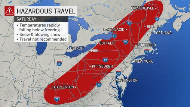
Travel will become treacherous, due to the freeze-up alone, in this zone, and AccuWeather forecasters warn that people should avoid travel if possible. Conditions will be particularly dangerous as heavy snow first begins on Friday night into Saturday. Meteorologists say this is the type of setup that can lead to cars sliding off roads, major pileup accidents or potentially leave motorists stranded on highways.
Cities most likely to experience the blast of moderate to heavy snow and freeze-up include Knoxville, Tennessee; London, Kentucky; Charleston, West Virginia; Columbus, Ohio; Pittsburgh; Rochester, New York; and Burlington, Vermont.
AccuWeather forecasters warn that dangers from the storm won't end when the snow tapers off. Blowing and drifting snow will follow the storm as temperatures are forecast to plunge into the teens and even the single digits from the Appalachians on west Saturday night and over the interior Northeast on Sunday night.
Powerful storm to bury interior Northeast under heavy snow (Full Story) >>
About AccuWeather, Inc. and AccuWeather.com
AccuWeather, recognized and documented as the most accurate source of weather forecasts and warnings in the world, has saved tens of thousands of lives, prevented hundreds of thousands of injuries and tens of billions of dollars in property damage. With global headquarters in State College, PA and other offices around the world, AccuWeather serves more than 1.5 billion people daily to help them plan their lives and get more out of their day through digital media properties, such as AccuWeather.com and mobile, as well as radio, television, newspapers, and the national 24/7 AccuWeather Network channel. Additionally, AccuWeather produces and distributes news, weather content, and video for more than 180,000 third-party websites.
# # #


