


AccuWeather Update on potential northeast bomb cyclone
Media Advisory: AccuWeather Update on potential northeast bomb cyclone
AccuWeather expert meteorologists ready to provide updates to media working on stories related to the severe weather risk in the northeastern US 24/7. Please contact pr@accuweather.com or 310.508.0799 at any time to arrange interviews with AccuWeather experts or to request the most updated graphics for print or broadcast.
AccuWeather Global Weather Center – March 9, 2022 – A powerful and far-reaching storm will form at the end of the week and unload everything from heavy rain and gusty thunderstorms to high winds, snow and a rapid freeze-up across the eastern third of the United States.
AccuWeather’s expert meteorologists say confidence is growing for a significant storm that will bring wide-reaching impacts. According to AccuWeather Forecast Operations Director Daniel DePodwin:
- Some areas in the interior northeast during the storm may pick up over a foot of snow in only 6-8 hours.
- Travel will rapidly deteriorate Saturday with temperatures plummeting10-20 degrees on Saturday that can cause a rapid freeze up.
- From Philadelphia to Boston, high winds over 40 mph can lead to significant power outages Saturday. Those in the impacted areas are advised to keep cell phones charged. Heavy rain may cause ground and air travel disruptions.
- Dangerous travel conditions may persist due to blowing and drifting snow across the central Appalachians, interior New York and northern New England on Saturday.
Large late-week storm to form in East

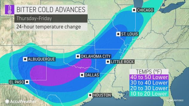


Along the leading edge of the push of cold air in the Plains, forecasters expect a new storm to develop near the Gulf Coast and track north-northeastward from Friday into the weekend.
This developing storm is expected to bring a wide variety of weather hazards that can disrupt travel and daily routines.
Accumulating snowfall is expected to extend from Oklahoma into the Tennessee and Ohio River Valleys on Friday, before extending snow northeastward through New England and southern Canada. A swath of 6-12″ inches of snow is forecast from the Appalachian Mountains of southwestern Virginia to the St. Lawrence River Valley of southern Quebec through Saturday. In much of this zone, the storm may begin as rain. As the storm ushers in colder air, the precipitation is forecast to change over to snow.
While the exact track of this storm will determine which areas get rain, snow or a combination of both as the system moves along this weekend, odds greatly favor just rain and perhaps even gusty thunderstorms along the I-95 corridor in the East.
High winds will also be of concern as the storm system moves along this weekend, with many in the eastern-third of the country likely to face an increased risk of tree damage and power outages.
For more information on this event, see the AccuWeather.com story here:
For the latest news and updates visit AccuWeather.com
About AccuWeather, Inc. and AccuWeather.com – AccuWeather, recognized and documented as the most accurate source of weather forecasts and warnings in the world has saved tens of thousands of lives, prevented hundreds of thousands of injuries and tens of billions of dollars in property damage. With global headquarters in State College, PA and other offices around the world, AccuWeather serves more than 1.5 billion people daily to help them plan their lives and get more out of their day through radio, television, newspapers, smart phones, tablets, connected TVs, the AccuWeather Network and AccuWeather.com. Additionally, AccuWeather produces and distributes news, weather content, and video for more than 180,000 third-party websites.